Calbuco Volcano Event, Chile - 2015
Campaign.CalbucoVolcano2015 History
Hide minor edits - Show changes to markup
http://media.npr.org/assets/img/2015/04/23/chile-calbuco_wide-ec9dce33f74a4c1970f589af2e55b56d580a68f9-s800-c85.jpg | Chile's Calbuco volcano is seen from the town of Puerto Montt on Wednesday, April 22, 2015, as it spews a high column of ash and lava. Photo: Diego Main/AFP/Getty Images LINK
http://media.npr.org/assets/img/2015/04/23/chile-calbuco_wide-ec9dce33f74a4c1970f589af2e55b56d580a68f9-s800-c85.jpg | Chile's Calbuco volcano is seen from the town of Puerto Montt on Wednesday, April 22, 2015, as it spews a high column of ash and lava. Photo: Diego Main/AFP/Getty Images LINK
http://media.npr.org/assets/img/2015/04/23/chile-calbuco_wide-ec9dce33f74a4c1970f589af2e55b56d580a68f9-s800-c85.jpg | Chile's Calbuco volcano is seen from the town of Puerto
Montt on Wednesday, April 22, 2015, as it spews a high
column of ash and lava.
Photo: Diego Main/AFP/Getty Images LINK
http://media.npr.org/assets/img/2015/04/23/chile-calbuco_wide-ec9dce33f74a4c1970f589af2e55b56d580a68f9-s800-c85.jpg | Chile's Calbuco volcano is seen from the town of Puerto Montt on Wednesday, April 22, 2015, as it spews a high column of ash and lava. Photo: Diego Main/AFP/Getty Images LINK
http://media.npr.org/assets/img/2015/04/23/chile-calbuco_wide-ec9dce33f74a4c1970f589af2e55b56d580a68f9-s800-c85.jpg | Chile's Calbuco volcano is seen from the town of Puerto \\
http://media.npr.org/assets/img/2015/04/23/chile-calbuco_wide-ec9dce33f74a4c1970f589af2e55b56d580a68f9-s800-c85.jpg | Chile's Calbuco volcano is seen from the town of Puerto \\
http://media.npr.org/assets/img/2015/04/23/chile-calbuco_wide-ec9dce33f74a4c1970f589af2e55b56d580a68f9-s800-c85.jpg | Chile's Calbuco volcano is seen from the town of Puerto
Montt on Wednesday, April 22, 2015, as it spews a high
column of ash and lava.
Photo: Diego Main/AFP/Getty Images LINK
April, 30th
This is the last information from Chilean volcanic services.
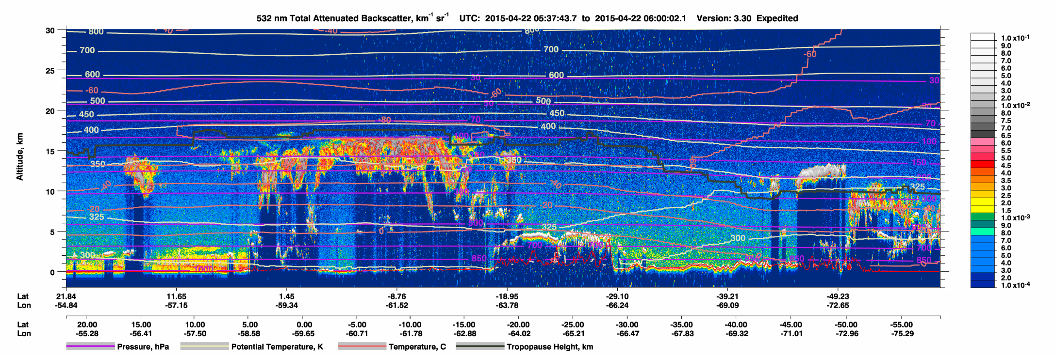
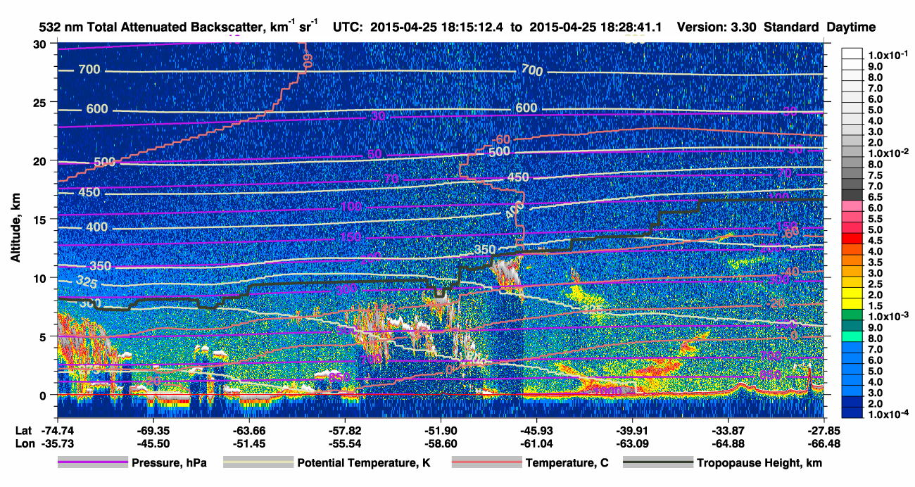
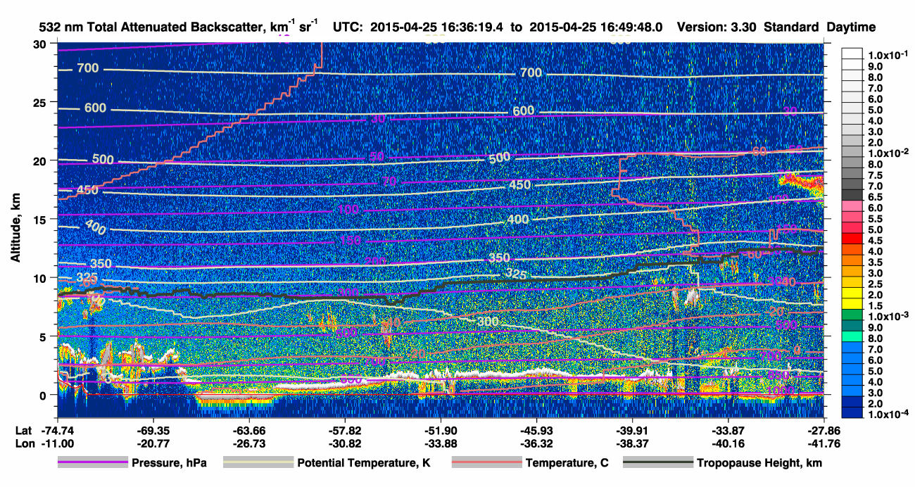
Following the plume with calipso, 29-Apr-2015 - Click the image for larger version
Following the plume with calipso, 29-Apr-2015 - Click the image for larger version. See also: http://www-calipso.larc.nasa.gov/products/lidar/browse_images/show_date.php?s=expedited&v=V3-30&browse_date=2015-04-28
and also from the AUGER team, the cosmic rays observatory in Mendoza-AR! The send a 23-page report of their Lidar observations close to Calbuco:
and also from the AUGER team, the cosmic rays observatory in Mendoza-AR! They sent a 23-page report of their Lidar observations close to Calbuco:
Click the image for larger version
and also from the AUGER team, the cosmic rays observatory in Mendoza-AR! The send a 23-page report of their Lidar observations close to Calbuco:
Dear all,
this is a report of the AUGER Raman lidar observations after the Calbuco eruptions.
Please forward to whom it may concern.

Best Regards

Vincenzo for the CRLF people and AUGER collaboration.

--
Vincenzo Rizi
CETEMPS/Dipartimento di Scienze Fisiche e Chimiche
Università Degli Studi dell'Aquila
LINK TO AUGER REPORT, UPDATED April 29
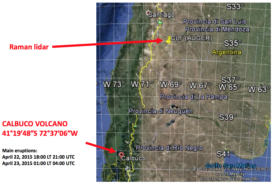
Location of AUGER x Calbuco - Click the image for larger version
Following the plume with calipso, 29-Apr-2015
Following the plume with calipso, 29-Apr-2015 - Click the image for larger version
|Following the plume with calipso, 29-Apr-2015
Following the plume with calipso, 29-Apr-2015
April, 29th
And today we got news from the CALIPSO team:
hey Eduardo and Fabio...

cool web site!

are you taking data pretty much continuously?
if so, then (based on CALIPSO images) I bet you're seen a much stronger
plume now, eh?  it looks like the plume is moving north and east fairly
rapidly...

Mark
Click the image for larger version |Following the plume with calipso, 29-Apr-2015
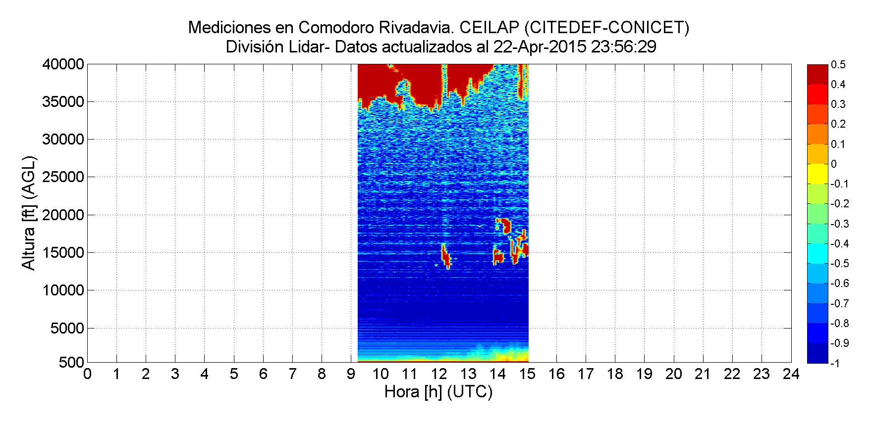
Comodoro Rivadavia RCS quicklook, April 22nd - Eruption day
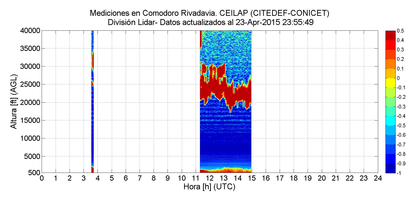
Comodoro Rivadavia RCS quicklook, April 23rd
or our summary page:
or our Lalinet page with all Argentina's lidar Real-Time quicklooks.
we have also put together a page for all data from Argentina since April 22nd: Quick looks from Argentina since 22nd
All lidars in Argentina are fully operational:
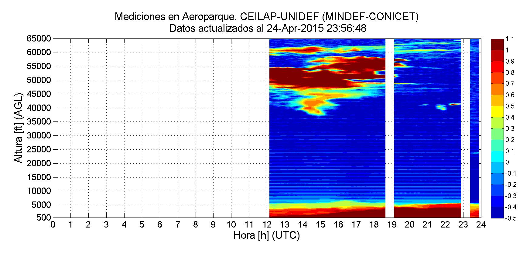
Aeroparque RCS quicklook, April 24rd
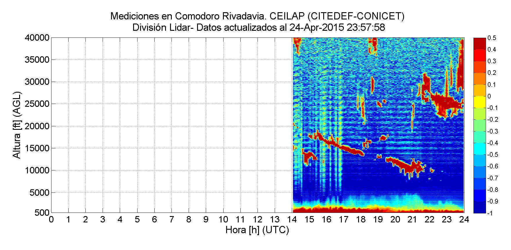
Comodoro Rivadavia RCS quicklook, April 24rd
Rio Gallegos RCS quicklook, April 24rd
Bariloche RCS quicklook, April 24rd
Attach:Aeroparque_20150427.png Δ|Buenos Aires - Aeroparque RCS for 27-Apr-2015
Buenos Aires - Aeroparque RCS for 27-Apr-2015
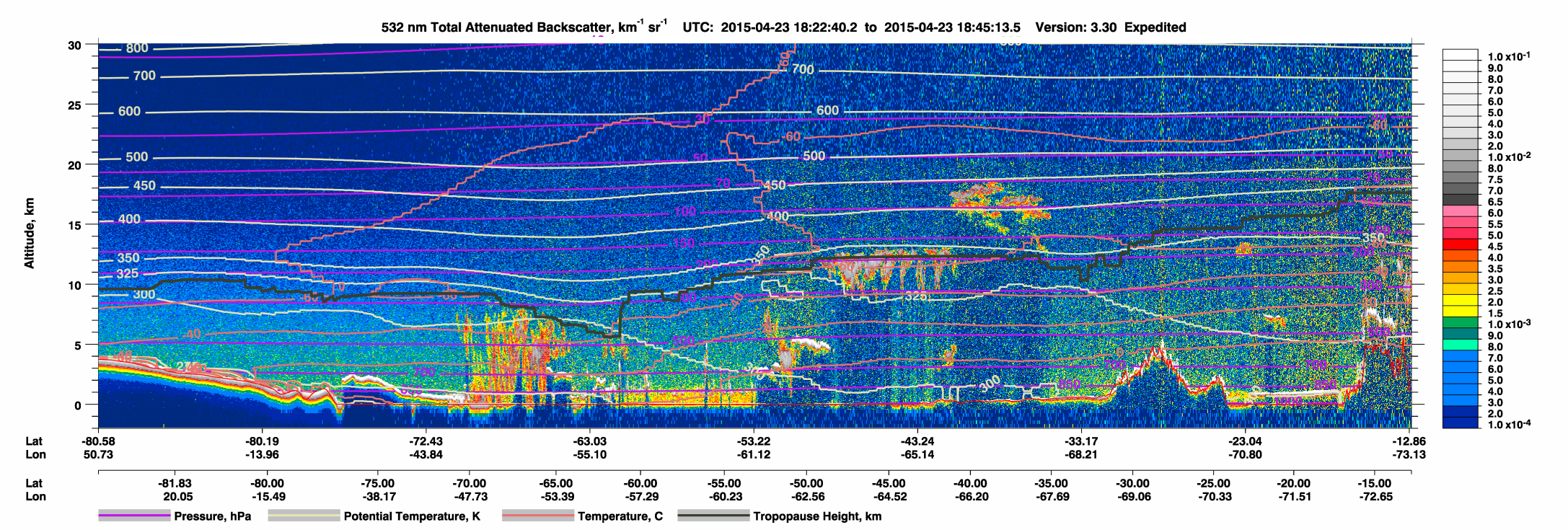
Attach:20150423argentinaCALIPSO/2015_04_23_CALIPSO_KMZ_Argentina_02.tif | Calipso overpass on April 23nd. Click to see all CALIPSO data.
Calipso overpass on April 23nd. Click to see all CALIPSO data.
This is the Calipso overpass on the day of the eruption.

Calipso overpass on April 23nd. Click to see all CALIPSO data.
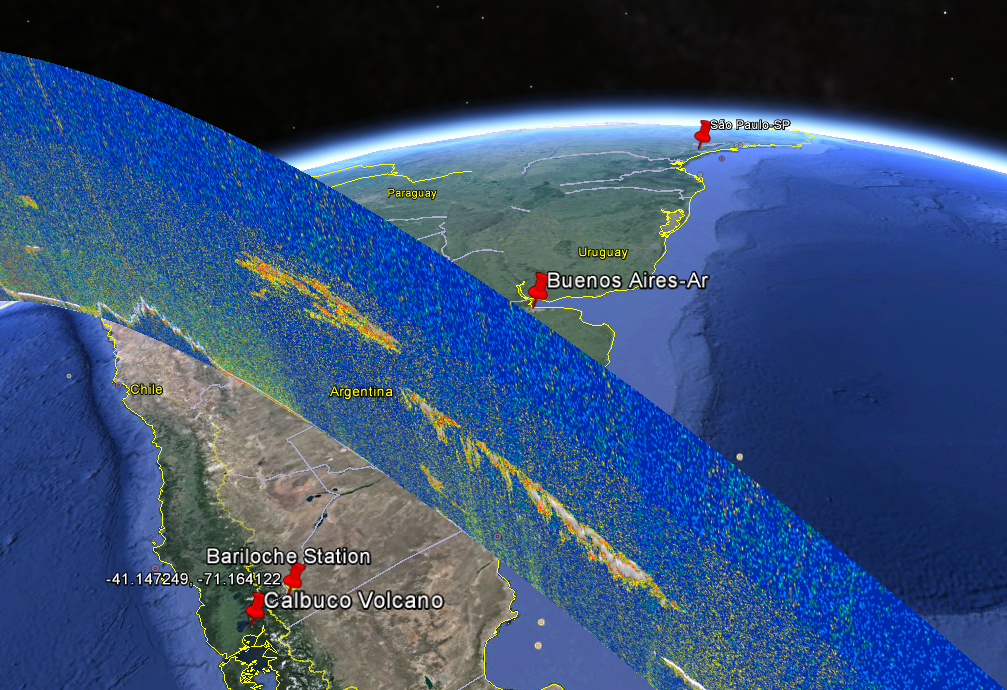
The next day, the plume was already travelling towards Buenos Aires, as can be seen in the Caliso data shown in the GoogleEarth below.
Attach:20150423argentinaCALIPSO/2015_04_23_CALIPSO_KMZ_Argentina_02.tif | Calipso overpass on April 23nd. Click to see all CALIPSO data.
Attach:20150424CALIPSO/2015-04-24_17-31-56_V3.30_map_2.png Δ | Calipso overpass on April 24nd. Click to see all CALIPSO data.
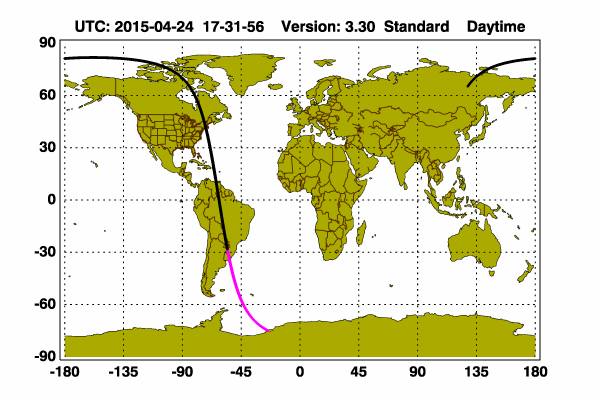
Calipso overpass on April 24nd. Click to see all CALIPSO data.
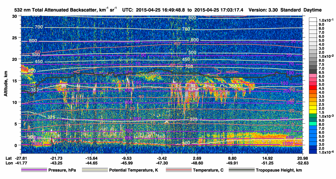
Attach:20150425argentinaCALIPSO/2015-04-25_18-15-14_V3.30_map_2.png Δ
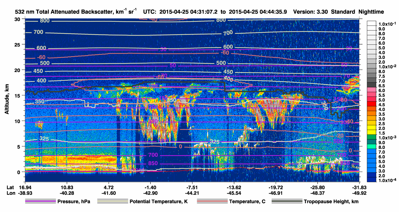
Attach:20150425bCALIPSO/2015-04-25_16-36-24_V3.30_map_2.png Δ


Calipso overpass on April 22nd. Click to see all CALIPSO data.
Calipso overpass on April 22nd. Click to see all CALIPSO data.
Calipso overpass on April 23nd. Click to see all CALIPSO data.
Calipso overpass on April 23nd. Click to see all CALIPSO data.
Attach:20150424CALIPSO/2015-04-24_17-31-56_V3.30_map_2.png Δ | Calipso overpass on April 24nd. Click to see all CALIPSO data.
Attach:20150424CALIPSO/2015-04-24_17-31-56_V3.30_map_2.png Δ | Calipso overpass on April 24nd. Click to see all CALIPSO data.
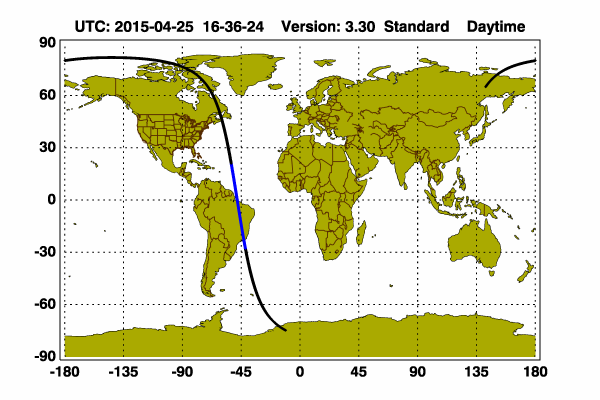

Attach:20150425argentinaCALIPSO/2015-04-25_18-15-14_V3.30_map_2.png Δ
Attach:20150425bCALIPSO/2015-04-25_16-36-24_V3.30_map_2.png Δ
Calipso overpass on April 22nd. Click to see all CALIPSO data.
Calipso overpass on April 22nd. Click to see all CALIPSO data.
Calipso overpass on April 23nd. Click to see all CALIPSO data.
Calipso overpass on April 23nd. Click to see all CALIPSO data.
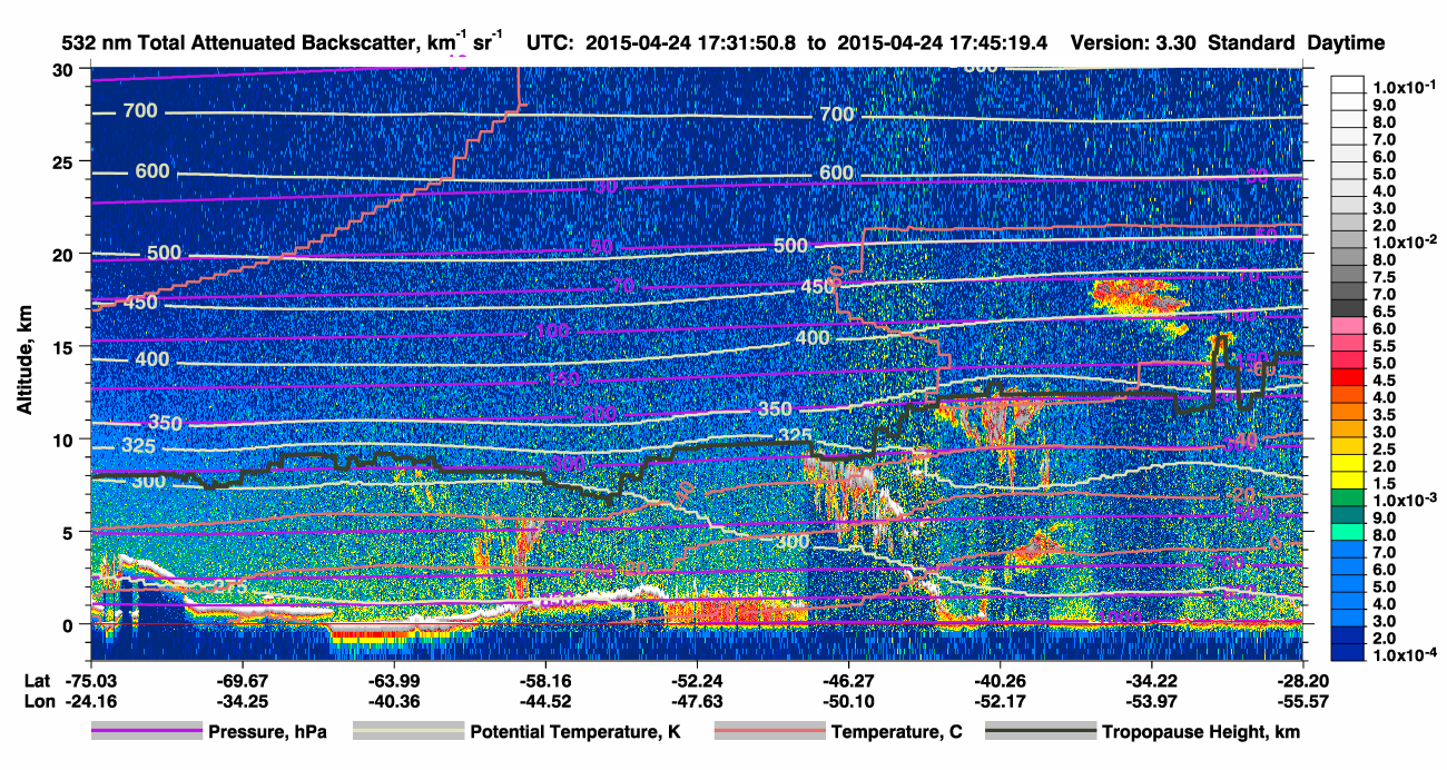
Calipso overpass on April 24nd. Click to see all CALIPSO data.
Attach:20150424CALIPSO/2015-04-24_17-31-56_V3.30_map_2.png Δ | Calipso overpass on April 24nd. Click to see all CALIPSO data.
Calipso overpass on April 24nd. Click to see all CALIPSO data.
April, 25th
Attach:20150423argetinaCALIPSO/2015-04-23_18-00-00_Exp_V3.30_2_1_overplot.png Δ | Calipso overpass on April 23nd. Click to see all CALIPSO data.
Calipso overpass on April 23nd. Click to see all CALIPSO data.
Attach:20150423argetinaCALIPSO/2015-04-23_18-00-00_Exp_V3.30_2_1_overplot.png Δ? | Calipso overpass on April 23nd. Click to see all CALIPSO data.
Attach:20150423argetinaCALIPSO/2015-04-23_18-00-00_Exp_V3.30_2_1_overplot.png Δ | Calipso overpass on April 23nd. Click to see all CALIPSO data.
Attach:20150423argetinaCALIPSO/2015-04-23_18-00-00_Exp_V3.30_2_1_overplot.png Δ? | Calipso overpass on April 23nd. Click to see all CALIPSO data.
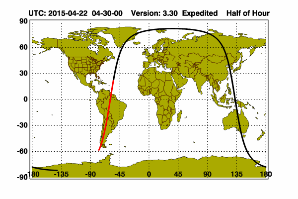
Calipso overpass on april 22nd. Click to see all CALIPSO data.
Calipso overpass on April 22nd. Click to see all CALIPSO data.
Calipso overpass on april 22nd.
Calipso overpass on april 22nd. Click to see all CALIPSO data. Attach:20150422argentinaCALIPSO/2015-04-22_04-30-00_Exp_V3.30_map_2.png
Measurements at La Paz, on the same, did not show any sign of the volcano plume.
Measurements at La Paz, on the same day, did not show any sign of the volcano plume.
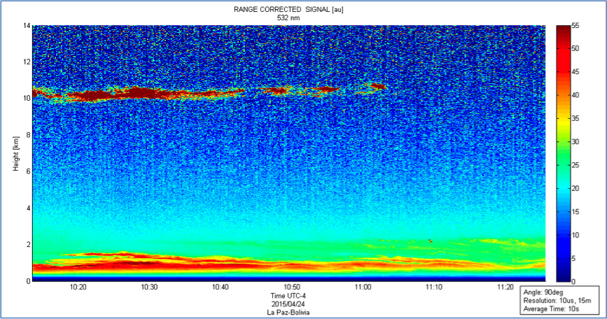
La Paz RCS quicklooks - April 24th
La Paz RCS quicklooks - April 24th. The signal at 10km is a Cirrus cloud.
Measurements at La Paz, on the same, did not show any sign of the volcano plume.
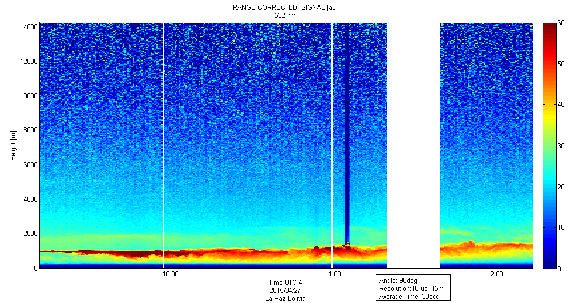
La Paz RCS quicklooks - April 27th.
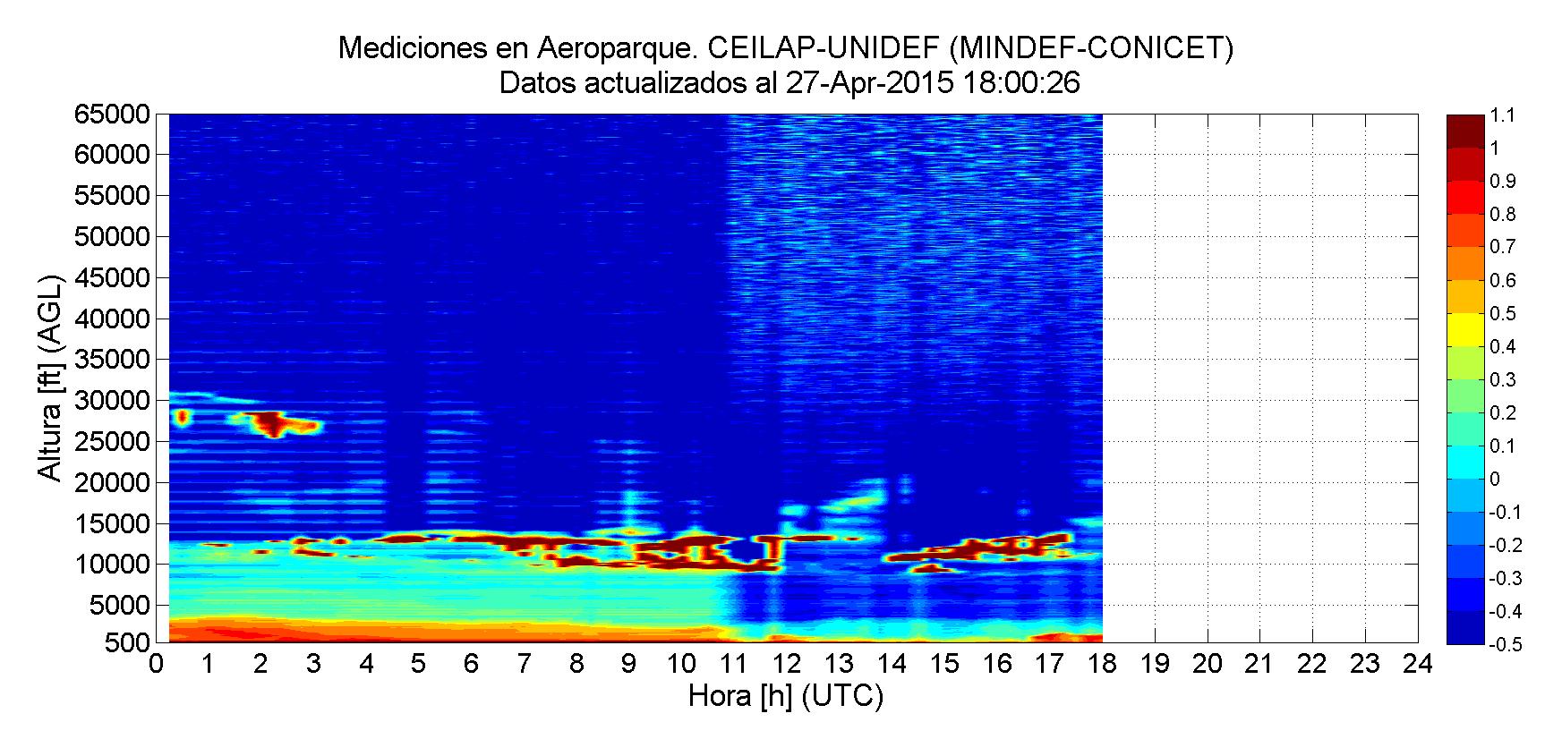
At the same time, Buenos Aires were able to see some kind of cirrus cloud (but in fact this "cloud" was actually volcanic ashes above 12 km up to 20 km)
Attach:Aeroparque_20150427.png Δ|Buenos Aires - Aeroparque RCS for 27-Apr-2015
RCS quicklooks - April 24th
RCS quicklooks - April 24th
La Paz RCS quicklooks - April 24th
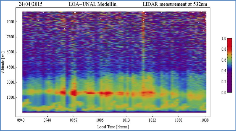
Medellin RCS quicklooks - April 24th
Attach:Lapaz_20150424.png|RCS quicklooks - April 24th
RCS quicklooks - April 24th
April, 25th
April, 26th
RCS quicklooks - April 24th
RCS quicklooks - April 24th
RCS quicklooks - April 24th
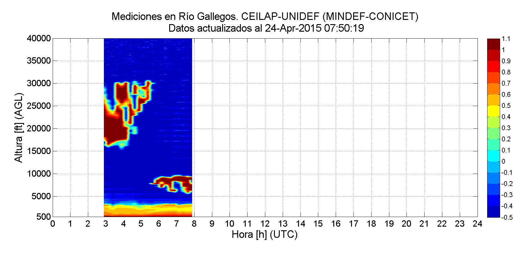
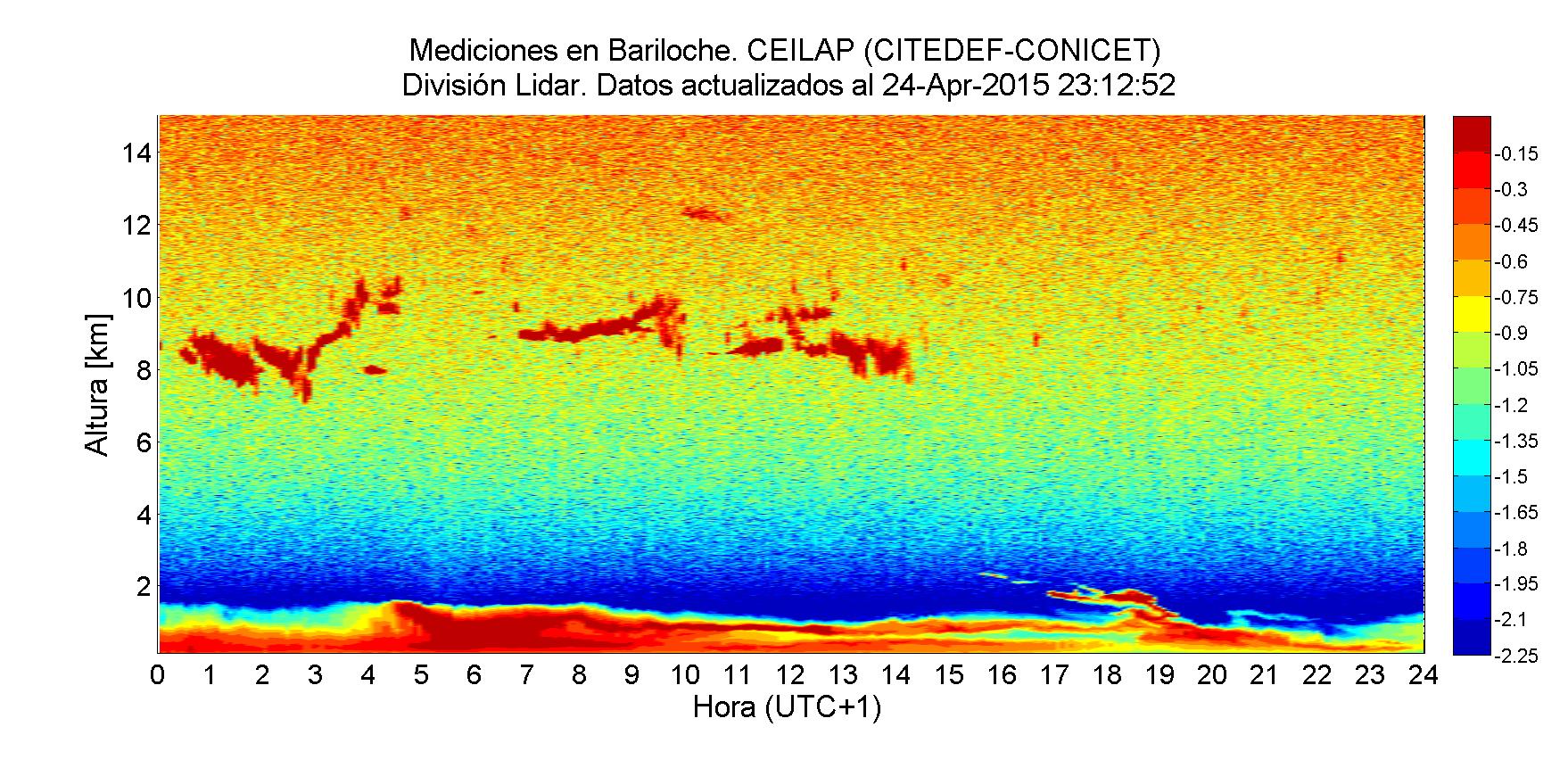
The fist observation came from Buenos Aires Aeroparque, Bariloche, Comodoro, Neuquen and Rio Gallegos stations : http://www.division-lidar.com.ar/lidaronline/aeroparque.html where plumes at heights from 3000 – 10000 m could be observed.
Lidars in Argentina in REAL TIME: http://www.division-lidar.com.ar/lidaronline/images/Nube3.JPG|Bariloche http://www.division-lidar.com.ar/lidaronline/images/Nube5.JPG|'Comodoro" http://www.division-lidar.com.ar/lidaronline/images/Nube7.JPG|Neuquén http://www.division-lidar.com.ar/lidaronline/images/Nube9.JPG|Aeroparque http://www.division-lidar.com.ar/lidaronline/images/Nube11.JPG|Río Gallegos
The fist observation came from Buenos Aires Aeroparque, Bariloche, Comodoro, Neuquen and Rio Gallegos stations, where plumes at heights from 3000 – 10000 m could be observed.
For real time data from Argentina, please see: http://www.division-lidar.com.ar/lidaronline
or our summary page: Quick looks from Argentina lidars in REAL TIME
A fast warning was made for the LALINET stations to start measuring the plume evolution in height and optical properties. In parallel HYSPLIT back and forward trajectories have been simulated.
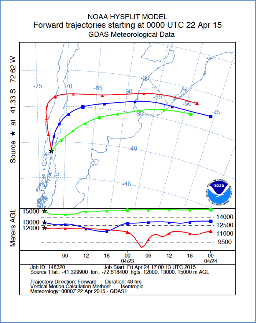
HYSPLIT forward trajectories starting at 22 of April 2015 at 00 UTC at the Calbuco Volcano coordinates.The trajectories at 12, 13 and 15 km are going towards to Buenos Aires – Argentina and the South region of Brazil
A fast warning was made for the LALINET stations to start measuring the plume evolution in height and optical properties. The Argentinian stations soon started to run as they already have an agreement with the national air traffic office and is in conducts operational measurements for ash identification and plume detection . Other stations in the continent started also special ops in order to observe plume events.
The Argentinian stations soon started to run as they already have an agreement with the national air traffic office and is in conducts operational measurements for ash identification and plume detection . Other stations in the continent started also special ops in order to observe plume events.
Lidars in Argetina in REAL TIME:
Lidars in Argentina in REAL TIME:
The lidar system in São Paulo detected a plume at 19000 m which could be a volcanic plume event which should be still confirmed.
Four days after the event started, the lidar system in São Paulo detected a plume at 19000 m which could be a volcanic plume event which should be still confirmed.
Other stations in the network were alert : La Paz (Bolivia) , Medellin (Colombia), Manaus (Brazil) and São Paulo (Brazil). These stations are far way from the event location and plume pathways, however started measuring.
April, 27th
The lidar system in São Paulo detected a plume at 19000 m which could be a volcanic plume event which should be still confirmed.
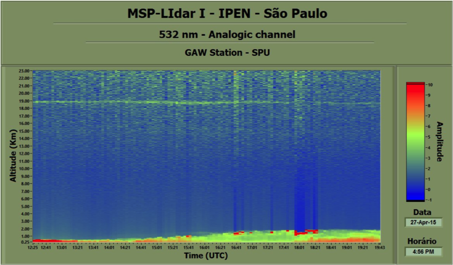
532nm Analog, Sao Paulo - 250m to 23km
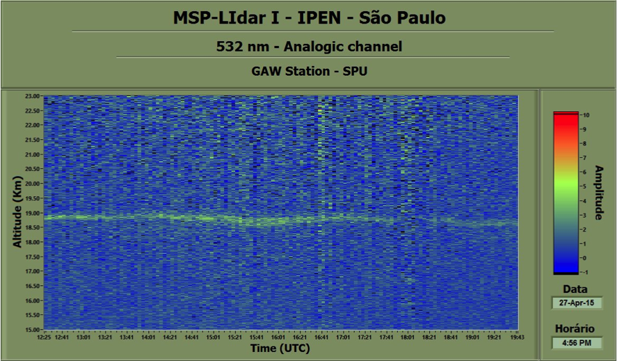
532nm Analog, Sao Paulo - 15km to 23km
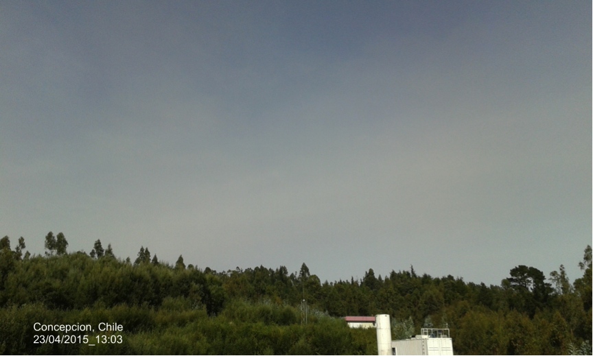
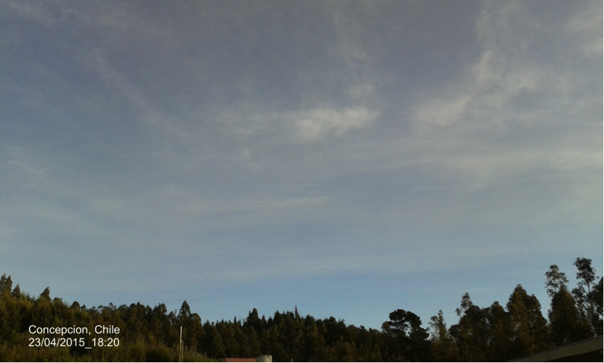
Soon after the lidar station in Concepcion, Chile, also observed the plumes, visually and with their lidar system.
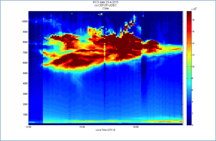
Concepcion Station lidar RCS quicklook – dust event observation on April 23rd 2015.
April, 23rd
Below there are MODIS’s images taken on April 23 revealing the fast displacement the ash plumes took right after.
MODIS’s images below were taken on April 23 revealing the fast displacement the ash plumes took right after. Satellite instruments also acquired unusual nighttime views of the eruption (below) in the early morning hours of April 23. The joint NOAA/NASA Suomi NPP satellite observed atmospheric waves above Calbuco and its plume.
April, 23rd
The fist observation came from Buenos Aires Aeroparque, Bariloche, Comodoro, Neuquen and Rio Gallegos stations : http://www.division-lidar.com.ar/lidaronline/aeroparque.html where plumes at heights from 3000 – 10000 m could be observed.
Lidars in Argetina in REAL TIME: http://www.division-lidar.com.ar/lidaronline/images/Nube3.JPG|Bariloche http://www.division-lidar.com.ar/lidaronline/images/Nube5.JPG|'Comodoro" http://www.division-lidar.com.ar/lidaronline/images/Nube7.JPG|Neuquén http://www.division-lidar.com.ar/lidaronline/images/Nube9.JPG|Aeroparque http://www.division-lidar.com.ar/lidaronline/images/Nube11.JPG|Río Gallegos
April, 24th
April, 25th
April, 26th
April, 27th
The fist observation came on April 27 from Buenos Aires Aeroparque, Bariloche, Comodoro, Neuquen and Rio Gallegos stations : http://www.division-lidar.com.ar/lidaronline/aeroparque.html where plumes at heights from 3000 – 10000 m could be observed.
http://www.division-lidar.com.ar/lidaronline/images/Nube3.JPG|Bariloche http://www.division-lidar.com.ar/lidaronline/images/Nube5.JPG|'Comodoro" http://www.division-lidar.com.ar/lidaronline/images/Nube7.JPG|Neuquén http://www.division-lidar.com.ar/lidaronline/images/Nube9.JPG|Aeroparque http://www.division-lidar.com.ar/lidaronline/images/Nube11.JPG|Río Gallegos
Satellite instruments also acquired unusual nighttime views of the eruption (below) in the early morning hours of April 23. The joint NOAA/NASA Suomi NPP satellite observed atmospheric waves above Calbuco and its plume.
http://eoimages.gsfc.nasa.gov/images/imagerecords/85000/85767/calbuco_tmo_2015113_lrg.jpg
http://eoimages.gsfc.nasa.gov/images/imagerecords/85000/85767/calbuco_amo_2015113_lrg.jpg
http://eoimages.gsfc.nasa.gov/images/imagerecords/85000/85767/calbuco_vir_2015113_lwir_lrg.jpg
http://eoimages.gsfc.nasa.gov/images/imagerecords/85000/85767/calbuco_tmo_2015113_lrg.jpg
http://eoimages.gsfc.nasa.gov/images/imagerecords/85000/85767/calbuco_amo_2015113_lrg.jpg
http://eoimages.gsfc.nasa.gov/images/imagerecords/85000/85767/calbuco_vir_2015113_lwir_lrg.jpg
http://eoimages.gsfc.nasa.gov/images/imagerecords/85000/85767/calbuco_tmo_2015113_lrg.jpg
http://eoimages.gsfc.nasa.gov/images/imagerecords/85000/85767/calbuco_amo_2015113_lrg.jpg
http://eoimages.gsfc.nasa.gov/images/imagerecords/85000/85767/calbuco_vir_2015113_lwir_lrg.jpg
http://eoimages.gsfc.nasa.gov/images/imagerecords/85000/85767/calbuco_tmo_2015113_lrg.jpg
http://eoimages.gsfc.nasa.gov/images/imagerecords/85000/85767/calbuco_amo_2015113_lrg.jpg
http://eoimages.gsfc.nasa.gov/images/imagerecords/85000/85767/calbuco_vir_2015113_lwir_lrg.jpg
A fast warning was made for the LALINET stations to start measuring the plume evolution in height and optical properties. The Argentinian stations soon started to run as they already have an agreement with the national air traffic office and is in conducts operational measurements for ash identification and plume detection www.division-lidar.com.ar . Other stations in the continent started also special ops in order to observe plume events.
A fast warning was made for the LALINET stations to start measuring the plume evolution in height and optical properties. The Argentinian stations soon started to run as they already have an agreement with the national air traffic office and is in conducts operational measurements for ash identification and plume detection . Other stations in the continent started also special ops in order to observe plume events.
Aeroparque: http://www.division-lidar.com.ar/lidaronline/images/Nube9.JPG Bariloche: http://www.division-lidar.com.ar/lidaronline/images/Nube3.JPG Comodoro: http://www.division-lidar.com.ar/lidaronline/images/Nube5.JPG Neuquén: http://www.division-lidar.com.ar/lidaronline/images/Nube7.JPG Río Gallegos: http://www.division-lidar.com.ar/lidaronline/images/Nube11.JPG
http://www.division-lidar.com.ar/lidaronline/images/Nube3.JPG|Bariloche http://www.division-lidar.com.ar/lidaronline/images/Nube5.JPG|'Comodoro" http://www.division-lidar.com.ar/lidaronline/images/Nube7.JPG|Neuquén http://www.division-lidar.com.ar/lidaronline/images/Nube9.JPG|Aeroparque http://www.division-lidar.com.ar/lidaronline/images/Nube11.JPG|Río Gallegos
(:Title Calbuco Volcano, Chile - 2015 :)
(:Title Calbuco Volcano Event, Chile - 2015 :)
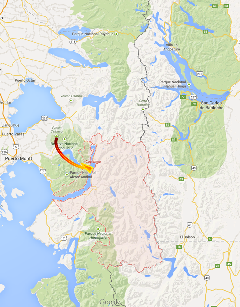
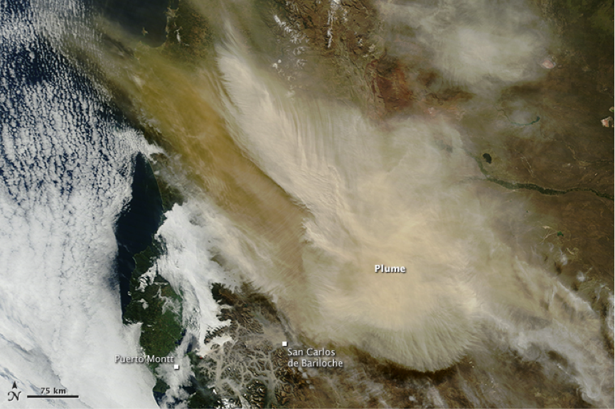
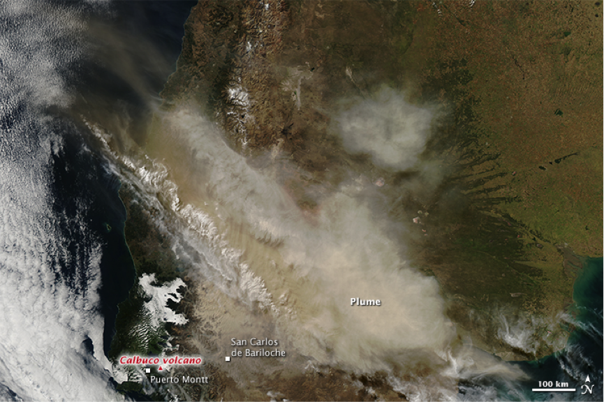
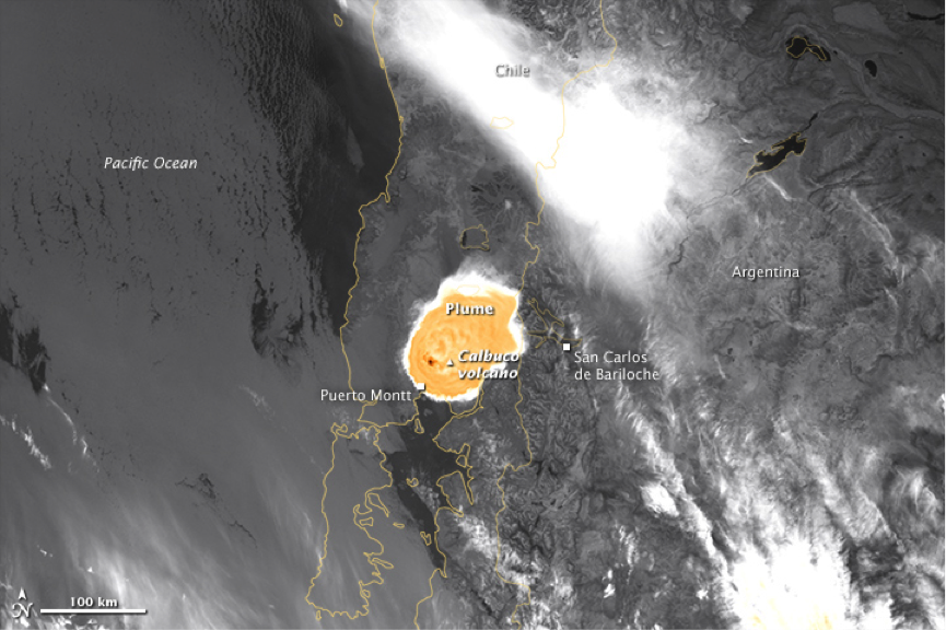
On April 22, 2015, Calbuco volcano in southern Chile began erupting for the first time since 1972. An ash cloud rose at least 15 kilometers (50,000 feet) above the volcano, the nearby communities of Puerto Montt (Chile) and San Carlos de Bariloche (Argentina) were evacuated in places where the ash load was considerable.
April, 23rd
Below there are MODIS’s images taken on April 23 revealing the fast displacement the ash plumes took right after.
http://eoimages.gsfc.nasa.gov/images/imagerecords/85000/85767/calbuco_tmo_2015113_lrg.jpg
http://eoimages.gsfc.nasa.gov/images/imagerecords/85000/85767/calbuco_amo_2015113_lrg.jpg
http://eoimages.gsfc.nasa.gov/images/imagerecords/85000/85767/calbuco_vir_2015113_lwir_lrg.jpg
A fast warning was made for the LALINET stations to start measuring the plume evolution in height and optical properties. The Argentinian stations soon started to run as they already have an agreement with the national air traffic office and is in conducts operational measurements for ash identification and plume detection www.division-lidar.com.ar . Other stations in the continent started also special ops in order to observe plume events.
April, 27th
The fist observation came on April 27 from Buenos Aires Aeroparque, Bariloche, Comodoro, Neuquen and Rio Gallegos stations : http://www.division-lidar.com.ar/lidaronline/aeroparque.html where plumes at heights from 3000 – 10000 m could be observed.
Aeroparque: http://www.division-lidar.com.ar/lidaronline/images/Nube9.JPG Bariloche: http://www.division-lidar.com.ar/lidaronline/images/Nube3.JPG Comodoro: http://www.division-lidar.com.ar/lidaronline/images/Nube5.JPG Neuquén: http://www.division-lidar.com.ar/lidaronline/images/Nube7.JPG Río Gallegos: http://www.division-lidar.com.ar/lidaronline/images/Nube11.JPG
Satellite instruments also acquired unusual nighttime views of the eruption (below) in the early morning hours of April 23. The joint NOAA/NASA Suomi NPP satellite observed atmospheric waves above Calbuco and its plume.